


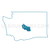
Denmark Voting District, Kittitas County, Washington
About
Outline

Summary
| Unique Area Identifier | 687345 |
| Name | Denmark Voting District |
| County | Kittitas County |
| State | Washington |
| Area (square miles) | 301.32 |
| Land Area (square miles) | 300.77 |
| Water Area (square miles) | 0.55 |
| % of Land Area | 99.82 |
| % of Water Area | 0.18 |
| Latitude of the Internal Point | 46.84653410 |
| Longtitude of the Internal Point | -120.24444680 |
Maps


Graphs
Select a template below for downloading or customizing gragh for Denmark Voting District, Kittitas County, Washington


Neighbors
Neighoring Voting District (by Name) Neighboring Voting District on the Map
- Firing Center Voting District, Yakima County, WA
- Kittitas 2 Voting District, Kittitas County, WA
- Lower Wenas Voting District, Yakima County, WA
- N Holland Voting District, Yakima County, WA
- Park Voting District, Kittitas County, WA
- Pomona Voting District, Yakima County, WA
- Thrall Voting District, Kittitas County, WA
- Vantage Voting District, Kittitas County, WA
Top 10 Neighboring County Subdivision (by Population) Neighboring County Subdivision on the Map
- Northeast Yakima CCD, Yakima County, WA (9,106)
- Northwest Yakima CCD, Yakima County, WA (8,252)
- Manastash Ridge CCD, Kittitas County, WA (5,238)
- Kittitas CCD, Kittitas County, WA (4,255)
Top 10 Neighboring Place (by Population) Neighboring Place on the Map
Top 10 Neighboring Unified School District (by Population) Neighboring Unified School District on the Map
- Ellensburg School District, WA (26,508)
- Selah School District, WA (18,675)
- Kittitas School District, WA (3,673)
- Damman School District, WA (769)
Top 10 Neighboring State Legislative District Lower Chamber (by Population) Neighboring State Legislative District Lower Chamber on the Map
Top 10 Neighboring State Legislative District Upper Chamber (by Population) Neighboring State Legislative District Upper Chamber on the Map
Top 10 Neighboring 111th Congressional District (by Population) Neighboring 111th Congressional District on the Map
Top 10 Neighboring Census Tract (by Population) Neighboring Census Tract on the Map
- Census Tract 9752, Kittitas County, WA (5,238)
- Census Tract 30.01, Yakima County, WA (4,584)
- Census Tract 9757, Kittitas County, WA (4,255)
- Census Tract 17.01, Yakima County, WA (3,083)